
The $37BN Road That's Changing a Country
- Youtube Views 1,394,117 VIDEO VIEWS

29 June 2022
Video hosted by Fred Mills. This video and article contain paid promotion for Bentley Systems.
EVERY year at the end of Ramadan, Indonesia sees one of the biggest migrations of people on earth. Tens of millions of people travel from major cities to their rural hometowns across the nation’s vast archipelago for Eid al-Fitr.
This mass exodus is known as mudik and let’s just say it makes Chris Rhea’s Driving Home for Christmas seem blissfully effortless by comparison. Special services are laid on for trains, ferries and planes. There’s even live coverage of the traffic as hundreds of thousands of people return to their hometowns and villages in Sumatra.

Above: Mudik sees millions of people take to the roads to return to their hometowns in time for Eid al-Fitr. Image courtesy of Coris.
It’s a major test for Indonesia’s transport infrastructure and, despite best efforts from the authorities, it has struggled to cope. Until now, that is.
This is all thanks to one of the biggest infrastructure projects in Southeast Asia, a network of new routes across Indonesia that includes the Trans Sumatera Toll Road which, when it’s completed, will span the entire length of the island.
Weaving through the dense rainforest and tropical conditions of Indonesia’s second largest island, building this massive road is far from easy – but it’s already having a big impact on Sumatra, and in more ways than one.
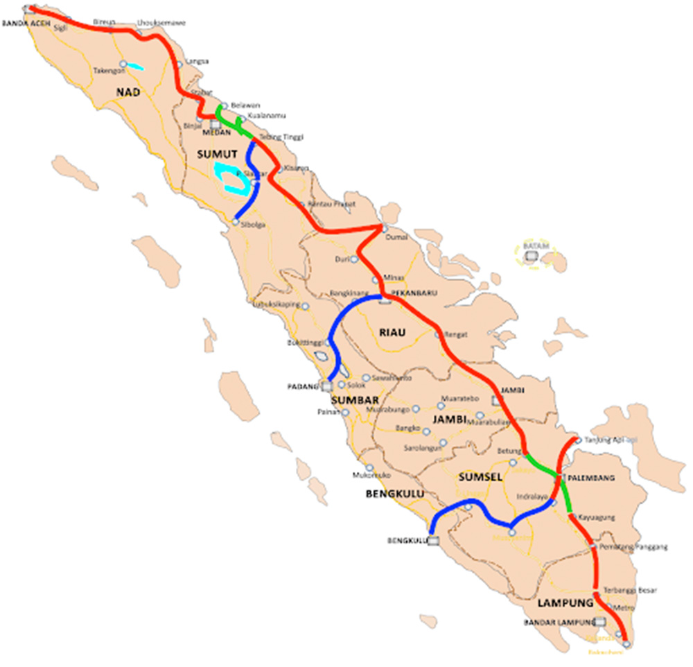
Above: Planned route of the Trans Sumatera Toll Road. Image courtesy of Hutama Karya.
Sumatra is roughly the size of California, and produces nearly a quarter of the country’s GDP. Despite that, getting around is not exactly straight forward. The island has a small and largely disconnected rail system, and travelling by road for any significant distance means you’re in for a bit of a bumpy ride.
The plan for the toll road, announced in 2015, would change all of that. Amy Widyastuti, BIM Manager at Indonesia’s state construction company Hutama Karya told us more:
“The initial plan for the Trans Sumatera Toll Road was to reduce the logistic cost and travel time across the island. The government wanted this to boost the economic growth of the island.”
The plan was huge. The road would stretch for nearly 3,000km from the port of Bakauheni in the south to the city of Banda Aceh in the north. The main highway would provide a direct route across the island and smaller roads would branch off to connect cities along the more remote western coast as well as key towns and ports to the east.
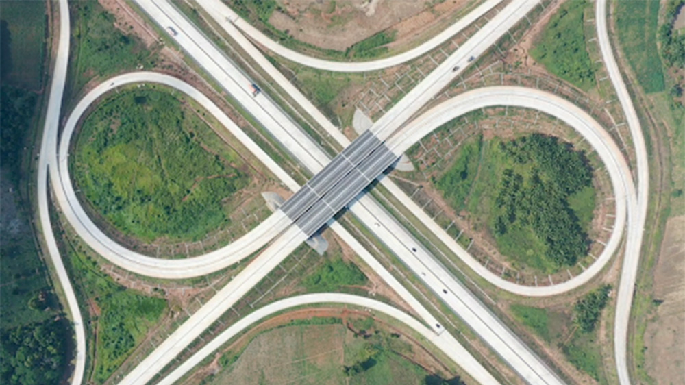
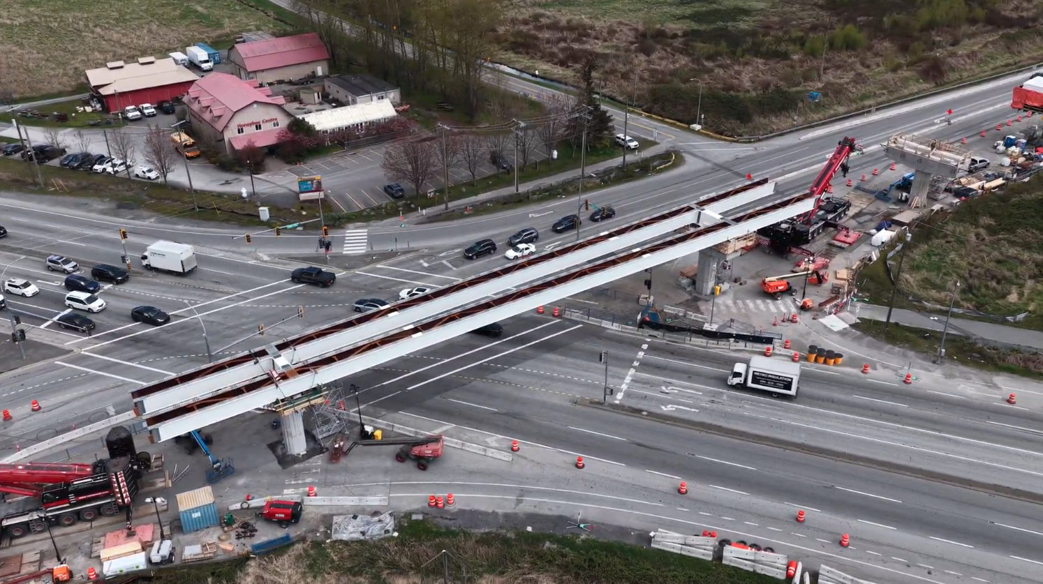
Above: An intersection on the Trans Sumatera Toll Road. Image courtesy of Hutama Karya.
It wasn’t cheap. An eye watering USD $37BN was earmarked to complete the project over a nearly decade long construction period. The contract was given to Hutama Karya and work began in 2015.
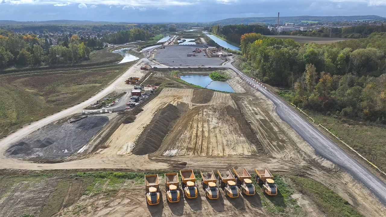
Ask any civil engineer to imagine the ideal conditions to build a road in and their wish list would probably read something like this: First you’d take a nice long flat stretch of ground and make sure there weren’t any rivers or other roads in the way which you’d have to build bridges over.
Ground conditions are pretty important. You’ll need strong, dry, well compacted soil which can cope well under the weight of all the traffic. Water is a big no-no as it can seep into the ground and weaken the foundations, and you’ll need to avoid any extremes of temperature and humidity which can also stress and degrade the quality of the road. Finally to make your life easier you’ll want to make sure the land you’re building on is clear of obstacles like trees, rocks and dense vegetation so you don’t have to waste any time clearing a path.
So, what’s it like in Sumatra?
Well, let’s just say vast swathes of the island are covered in some of the most dense, verdant jungles anywhere in the world … you get the idea.
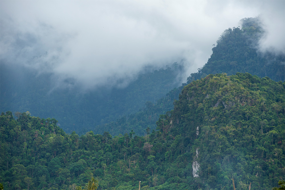
Above: Sumatra’s geography throws up pretty much every engineering challenge imaginable.
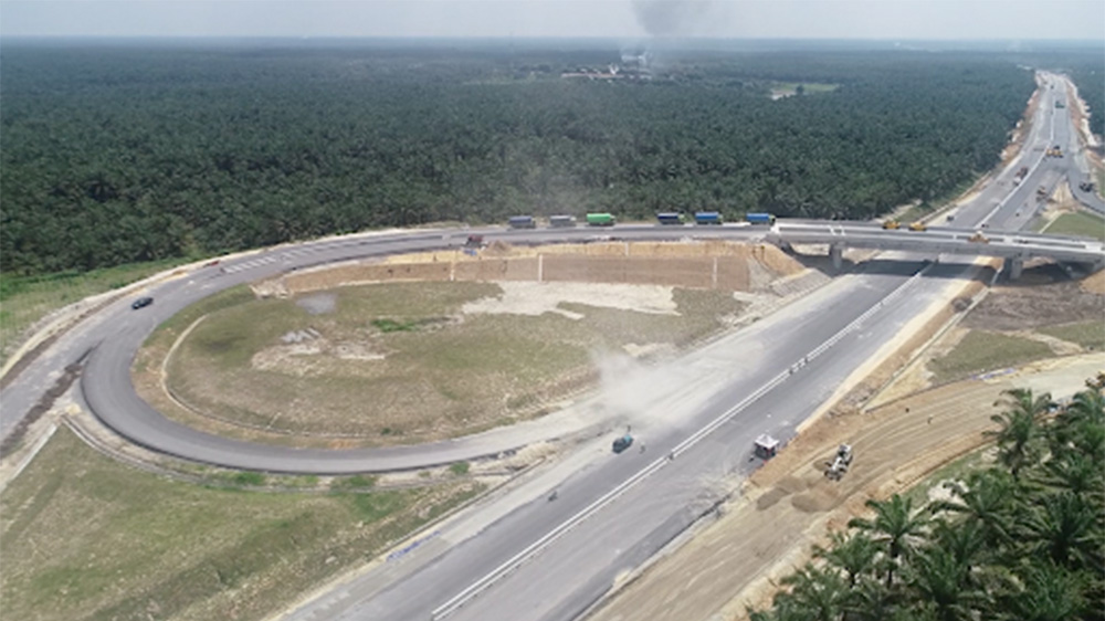
The 28km stretch of road between the city of Pematangsiantar and the town of Serbelawan is pretty typical of the kind of challenges faced. This key stretch of the road links the major city of Medan to the industrial port of Kuala Tanjung and the nearby tourist hotspot of Parapat.
The path for the road lay through dense, remote rainforest, and even just getting the survey done for it was never going to be easy. To solve these issues the team at Hutama Karya turned to high tech solutions such as LIDAR, which could then be integrated into infrastructure engineering software provided by Bentley Systems.
LIDAR is similar to sonar and radar in that it emits a pulse towards an object and measures the time for the pulse to return to calculate distance. With nearly half a million of these measurements made every second, the data that generates can create an incredibly accurate picture of the ground.

Above: LIDAR surveys were conducted using a drone.
LIDAR surveys are usually conducted from aeroplanes, but that was quickly ruled out as an expensive and impractical option for the Trans Sumatera Road. Instead the team used a drone, mapping the ground with a tolerance of 25cm throughout the route.
The laser pulses LIDAR uses provide other advantages aside from accuracy. Just like rays of light passing through a forest, the light from the laser beam is able to pass through soft vegetation. The strength of the light returned is measured to give a three dimensional picture of the survey area, allowing the team to map out the dense jungle.
As a result of this tech the survey for this stretch of the road took just 28 days: nearly 100 days quicker than originally planned.
But it’s more than just above ground conditions the team had to work through, being in a humid rainforest the ground beneath the construction site was far from perfect.
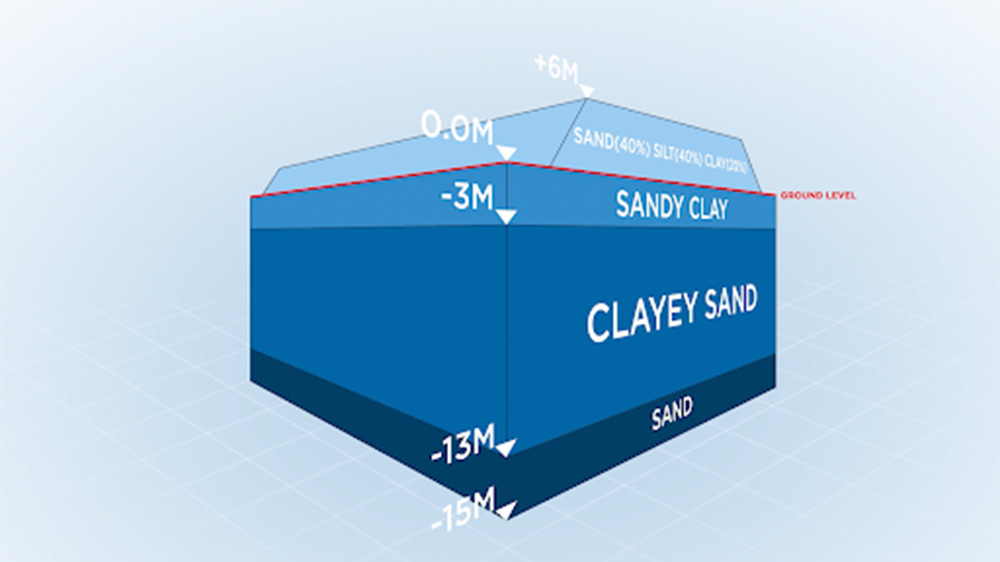
Above: Engineers had to manage deep areas of soft earth.
Soil samples showed areas of soft soil and clay 13 metres deep. You don’t need to be an engineer to realise that’s not the ideal conditions to build a road that hundreds of thousands of people are going to be driving on.
“The road will be crossed heavily by large trucks that will create cracks when the soil is not solid or reinforced,” Widyastuti said.
“To add stability, a fabric membrane known as a geotextile was laid under the six metre embankment. The geotextile basically consists of a non-woven, polyester and polypropylene sheet. It's a layer that can be thrown on the top of the soil to prevent soil displacement.”
Managing a project which includes everything from soil samples to LIDAR mapping needs a powerful set of tools to help make sense of the vast amount of data. For this, the team at Hutama Karya turned to Bentley Systems whose portfolio of programmes has made them an industry leader in infrastructure engineering software.
Bentley’s software is able to combine data from different sources, like the lidar scans, to create a complete digital model of the project, enabling the project team to visualise the job in a variety of ways.
Bentley LumenRT was used to create a visualisation of the road which was pretty central in identifying problems and displaying them in very visual ways. In one case the planned route clashed with an existing road and the visualisation was used to quickly identify the need for higher bridge clearance.
For a project reliant on state funding, advanced tech solutions like this are essential to keep costs down.
“We use all of these resources to create a digital transformation of the project, this way we can ensure that the toll road will be in the best quality for the next 40 or 60 years,” Widyastuti said.
Above: When completed the road will be a huge boon to industry. Image courtesy of Hutama Karya.
When the road is completed it will have major benefits for Sumatra’s economy. As well as a booming tourist industry, the island boasts enormous mineral wealth, which once earned it the nickname the Island of Gold.
Sumatra has huge deposits of oil, silver and coal and is a major producer of tea, coffee, rice and corn. With journey times due to be cut in half by the road and logistics costs reduced by 30 percent, these export industries will all benefit massively from the project.
But who will benefit from this economic development? We spoke to Irham Yunardi of the campaign group Forest, Nature and Environment of Aceh or HAkA.
“I don't doubt that it will support economic development as it supports connectivity and stuff. But there is a worry that it won’t be enjoyed by many.”
Existing roads set to be bypassed by the new toll route provide a valuable source of income for many of the island’s poorer citizens. Now, suggestions have been made to try and replicate their businesses along the new highway.
“Local communities have small, medium businesses like stalls in the road where a lot of people would come and stop by for their lunch, their meals, or even just have their cup of coffee when they're on a road trip break,” Yunardi explained.
“There should be some kind of allocation where existing businesses can open on the toll road where they plan to make rest areas. Will there be opportunities for existing communities to open there? If they do, will there be subsidies for them as well?”
As well as the human element, there’s also concern for Sumatra’s rich ecosystem, which hosts many critically endangered animals.
The branch road connecting the main highway to the city of Padang cuts across the border of the Kerenci Seblat National Park, the biggest of its kind on the island and one of the most important tiger conservation habitats in the world.
“Tigers are actually one of the key species of Sumatra that still remains in the wild," Yunardi said. "By fragmenting their roaming area through the road, there will be an increase of human wildlife conflict activities where tigers roam into community areas.”
In a place as verdant and wild as Sumatra economic development will almost always be at odds with the natural environment and there are no easy answers. Indonesia’s economic growth has helped reduce absolute poverty levels from over 70 percent in the 1980s to less than 10 percent today.
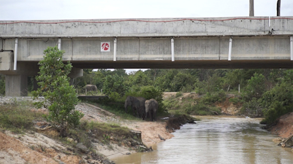
Above: Bridges have been constructed along the road to maintain roaming areas for elephants. Image courtesy of Hutama Karya.
Some concessions to wildlife have been made. In several areas, bridges were built where the road crossed with migratory paths of wild elephants. These bridges allow the elephants to roam freely without coming into conflict with the road.
The road may have its critics, but organisations like HAkA are looking for positive engagement with the development of the road.
“My personal view is that I'd like to be as helpful as possible,” Yundari said. “I think as long as there will be opportunities for civil society organisations to engage we will be able to take part and have our suggestions be considered and be implemented.”
Just over 650km of the road is currently operational, so there’s still some way to go if it’s to meet its planned completion date of 2024. Once fully open it’ll have a profound effect on the island and give Sumatra the key piece of modern infrastructure that it needs if it wants to grow further.
While the wider implications of this remain to be seen, anyone taking part in Mudik will definitely have an easier ride.
This video contains paid promotion for Bentley Systems, which helps architecture, engineering and construction firms worldwide accelerate project delivery and improve asset performance with cutting edge software solutions. Click here to learn more.
Video narrated by Fred Mills. Additional footage and images courtesy of Bentley Systems, Hutama Karya, Al Jazeera, CNA, Indonesia Morning Show Net, BeritaSatu.
We welcome you sharing our content to inspire others, but please be nice and play by our rules.
Comments